


Mostrando entradas con la etiqueta Capitais da América do Sul. Mostrar todas las entradas
Mostrando entradas con la etiqueta Capitais da América do Sul. Mostrar todas las entradas
domingo, 11 de noviembre de 2012
martes, 31 de enero de 2012
Puerto Madero (Buenos Aires - ARGENTINA). Puente de la Mujer de Santiago Calatrava


Foto: GUILLÉN & KALLAS ARQUITETURA


"El Puente de la Mujer es un puente giratorio diseñado por el arquitecto español Santiago Calatrava en la Ciudad de Buenos Aires, Argentina. Es la única de sus obras en América Latina y se encuentra ubicada en el Dique 3 de Puerto Madero, en Pierina Dealessi y Manuela Gorriti. Se trata de una obra pensada por el empresario Alberto González, quien fue miembro del Grupo Madero y donó el dinero para su construcción. González se la encargó al arquitecto e ingeniero español Santiago Calatrava Valls. Fue fabricado por la empresa Urssa en la ciudad de Vitoria, en el País Vasco, debido a que el acero con el que se lo construyó no se fabrica en la Argentina." (Fuente: Wikipedia)
sábado, 20 de agosto de 2011
As 4 escalas do Plano Piloto. Brasília - BRASIL
Brasília 50 anos -- Escalas do Plano Piloto: 1 - Área Residencial
Escala Residencial - Eixos arqueados, superquadras, pilotis, edifícios com gabaritos uniformes de seis andares, áreas verdes comuns a todos os moradores. Conheça nesse inter-programa o projeto de Lucio Costa para os habitantes do Plano Piloto.
Brasília 50 anos - Escalas do Plano Piloto: 2 - Gregária
Escala Gregária - Brasília tem setores reservados para hotéis, bancos, comércio e diversão. Espaços organizados para a multidão e propícios ao encontro. A plataforma rodoviária é o ponto de convergência desses setores. Para entender é só assistir a esse inter-programa.
Brasília 50 anos - Escalas do Plano Piloto: 3 - Monumental
No eixo retilíneo do Plano Piloto estão os principais monumentos de Brasília. Lucio Costa desejava uma cidade monumental mas sem ostentação. Essa missão coube a Niemeyer. Veja, nesse inter-programa, como foi pensado e como ficou o projeto de Lucio Costa.
Brasília 50 anos - Escalas do Plano Piloto: 4 - Escala Bucólica
Uma cidade sem muralhas. Áreas livres, arborizadas. Gramados concebidos como tapetes. O verde dá ritmo e harmonia ao Plano Piloto. Nesse interprograma é possivel conhecer o projeto de Lucio Costa para uma Brasília bucólica.
miércoles, 2 de febrero de 2011
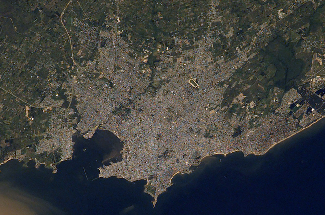
Montevideo (URUGUAY)
 link here...
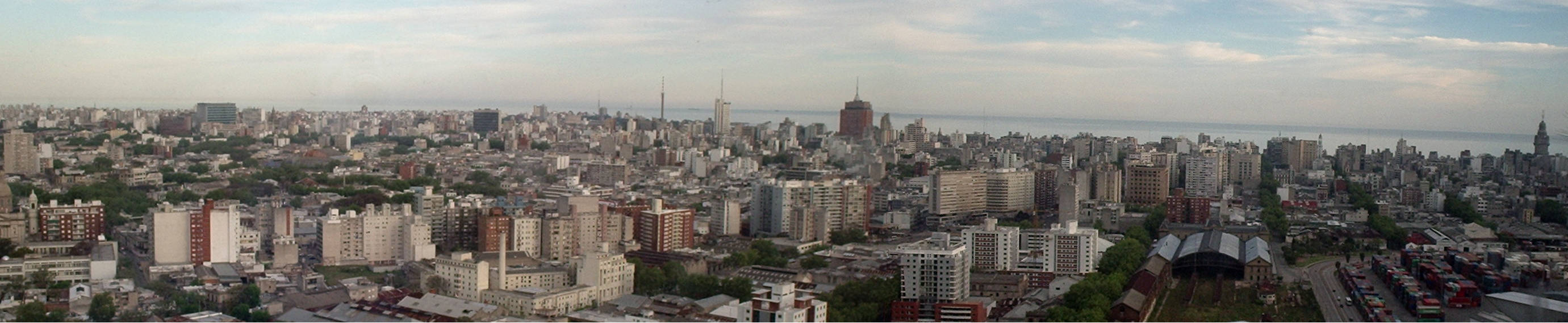
Montevideo (Spanish pronunciation: [monteβiˈðeo]) is the largest city, the capital, and the chief port of Uruguay. The settlement was established in 1726 by Bruno Mauricio de Zabala, as a strategic move amidst a Spanish-Portuguese dispute over the Viceroyalty of the Río de la Plata, and as a counter to the Portuguese colony at Colonia del Sacramento. According to the census of 2004, Montevideo has a population of 1,325,968 (about half of Uruguay's population).[8] It has an area of 530 square kilometres (200 sq mi) and extends 20 kilometres (12 mi) from west to east. The southernmost cosmopolitan capital city in the Americas and third most southerly in the world, it is situated in the southern coast of the country, on the northern bank of the Río de la Plata (also River Plate), an arm of the Atlantic Ocean. The city was under brief British rule in 1807 and was involved in the first major naval battle in the Second World War: the Battle of the River Plate. It is also the place where the Montevideo convention was signed in 1933 by nineteen nations of the Americas. The city hosted all 1st FIFA World Cup matches in 1930. Montevideo has a rich architectural and cultural heritage, the latter including tango and candombe. According to Mercer Human Resource Consulting, in 2007 Montevideo provided the highest quality of life in Latin America.[2][3][4][5][6][7]
Described as a "vibrant, eclectic place with a rich cultural life", it is the hub of commerce and higher education in Uruguay: its first university, the "Universidad de la República", was founded in 1849.[2][4][9] The architecture of Montevideo, considered unrivalled in South America, reflects its history, ranging from colonial to Art Deco, and influenced by Spanish, Portuguese, Italian, French and British immigrants.[2][3][10] (Source: Wikipedia)
Suscribirse a:
Entradas (Atom)